
Powerful Pacific Storms Amid 'Super' El Niño
Air Date: Week of October 16, 2026
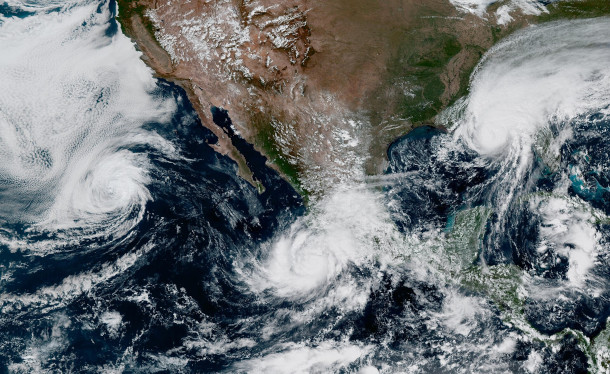
Tropical Storm Rachel, Hurricane Simon, and Hurricane Isaias simultaneously surround the United States. Due to this year’s particularly strong El Niño, the number of Pacific storms are at a record high. (Photo: NASA, Wikimedia Commons, public domain)
Boosted by climate change, this year’s El Niño has intensified into a “Super El Niño,” meaning sea surface temperatures in parts of the Pacific are over 2 degrees Celsius hotter than average. Seth Borenstein of the Associated Press talks with Host Paloma Beltran about how this has brought one strong storm after another churning across the Pacific Ocean while shutting down most Atlantic storms, and what this super El Niño may bring in the months ahead.
Transcript
O’NEILL: From PRX and the Jennifer and Ted Stanley Studios at the University of Massachusetts Boston, this is Living on Earth. I’m Aynsley O’Neill.
BELTRAN: And I’m Paloma Beltran.
El Niño and La Niña are opposite phases of a natural climate cycle that shifts ocean temperatures and winds across the tropical Pacific Ocean every 2 to 7 years. Fueled by climate change, this year’s El Niño has intensified into a “Super El Niño,” meaning sea surface temperatures in parts of the Pacific are over 2 degrees Celsius hotter than average. And it’s brought one strong storm after another churning across the ocean. Seth Borenstein is a science writer at the Associated Press, and we called him up for an overview of what we can expect in the months ahead.
BORENSTEIN: This is, by all accounts, forecast to be the strongest El Niño that's been recorded in modern times, and perhaps for at least 1000 years using coral records. What El Niño does is it sort of warps weather worldwide. It just changes everything. It's sort of a chaos agent, and so during an El Niño, the biggest effect is that the globe in general gets warmer, and it's strangely - there's a delayed effect. So the El Niño has started this summer. It's expected to peak in about a month or two. Yet, that means that it usually will cause the next year to be a record-warm year. This is a super El Niño, and it is so strong that this year may be a record year. But even if 2026 is a record warm year, it is incredibly likely to be broken by 2027. But I think what we're mostly here to talk about is what El Niño does to hurricanes and typhoons, especially hurricanes in the Atlantic, which is, you know, where Florida, the Gulf of Mexico is. El Niño sort of just smothers hurricanes. Basically, you get far fewer hurricanes, and until a week or so ago, we had zero hurricanes. We had a few named tropical storms. We had our first hurricane in Isaias. I'm sorry, I'm very bad at pronouncing it, and that was the first hurricane of the season. And it was one of the latest first hurricanes of the season in decades. You have to go back to 1914, when there were no hurricanes that season in the Atlantic. But of course, they weren't monitoring as well, so there may have been, and they just didn't see it.
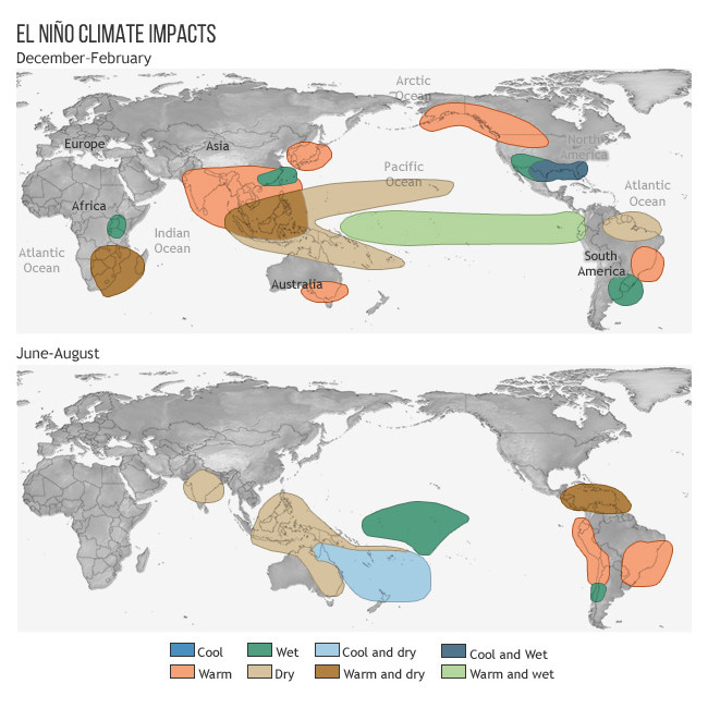
The above graphic shows global weather impacts of the El Niño pattern throughout a year’s time. (Graphic: Rebecca Lindsey and Tom Di Liberto, NOAA, Wikimedia Commons, public domain)
BELTRAN: Yeah, so it's kind of slowed down in in the Atlantic, from what I'm understanding here.
BORENSTEIN: I would say it's not just slowed down; it's in a coma in the Atlantic. And that's a good thing if you live there. But in the Pacific, it does the opposite. In the Pacific region, it is sort of like fuel for hurricanes. It makes the Pacific go nuts. The Pacific hurricane season this year has been at a record level.
BELTRAN: Seth, what are those hurricanes, and what impact have they had across the Pacific?
BORENSTEIN: Since mid-September, you've had Nolo, Odalys, Polo, Rachel, and Simon, and then we have Trudy gearing up right now. So, the best way to measure sort of the nastiness of a hurricane season is by something that meteorologists call ACE, which is Accumulated Cyclone Energy, which sounds highfalutin, but all it is is calculating how strong storms get by their wind speed and how long they last. I'm fascinated with Polo, even though Polo did very little damage. The world, especially Mexico, was very lucky with Polo. Polo passed the record from just 2018 for highest days. Polo set a record for the most days at category five in the Pacific, and it was a monster, but it luckily weakened before it hit, and it hit in an area of Baja California that is relatively less inhabited. So it it caused less damage than it could have. Basically, we were all lucky. These are storms that had they had a different track, sort of like Otis a couple years ago, they could have been incredibly deadly, so we've been lucky.
BELTRAN: So, what is it about an El Niño that makes these storms so potent?
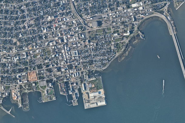
Aerial view of Pensacola, Florida, an area that suffered from heavy flooding in the aftermath of Hurricane Isaias. Photo captured on October 11, 2026. (Photo: NOAA, NOAA.gov, public domain)
BORENSTEIN: What an El Niño does is it takes away one of the things that just shuts hurricanes down, and that's winds, high-level winds that decapitate a hurricane. So if you're looking in the Atlantic, El Niño has put those winds on high, and nothing's happening. It's like a red light for cars. In the Pacific, it's different if those winds are incredibly weak, and it's like a green light, so if all the other conditions are favorable, which they are, then hurricanes just rev up and go.
BELTRAN: To what extent can we tell the impact from climate change on this particular El Niño event?
BORENSTEIN: On this El Niño event, scientists have said that there is a factor because what we are seeing is more and more large-scale El Niños. So they are seeing some factor in making El Niños stronger, but it's still not enough for them to really be conclusive. One of the odd things that they're noticing also is we get more of the La Niñas, which are the opposite ends, but when we get El Niños, they're stronger.
BELTRAN: And now I understand you recently covered a new study about El Niño. What can you tell me about that, Seth?
BORENSTEIN: So this new study looked at Hurricane Polo, which fortunately didn't cause much damage, because it weakened before it hit in Mexico. But it was a record hurricane for the number of days at the top of the scale, category five. So, the two major climate attribution teams, which are World Weather Attribution, which is an international group, and Climate Central out of Princeton, New Jersey, they teamed up and looked at Hurricane Polo and what caused it to strengthen. They didn't look at the winds that we talked about earlier that can either decapitate or not hinder a hurricane. They looked at the fuel, which is, for a hurricane, is warm water, and they looked at it two different ways and found the same thing. They found that climate change, human-caused climate change, made a storm like Polo, super strength storm, 23 times more likely. El Niño made it 14 times more likely, so they both together combined to make this storm more likely. But if you're looking at culprits, climate change was a slightly bigger culprit than El Niño, and they said that climate change added about six miles per hour to the wind strength of Polo, and that El Niño added a little bit less. Altogether, Polo would have been still at top of the category five hurricane without climate change, without El Niño, but then these sort of revved it up a little more.
BELTRAN: Seth, what can we expect in the coming weeks with this major El Niño event that we're experiencing?
BORENSTEIN: Well, I think we could expect more of the same, which is a quiet Atlantic hurricane season, a busy Pacific hurricane season. But you also see, because El Niño is that weather chaos agent, it'll cause flooding in all sorts of places and drought in other places. One of the biggest effects of El Niño is on Indonesia and South American drought, and also heavy on the fisheries in South America. And so we will see usually during an El Niño, and this is quite an El Niño, we see an increase in Indonesian fires, which we're already seeing. We'll see more drought in certain places, more flooding in other areas, and there have been economic studies that show El Niño, generally for the world, is incredibly expensive. Past El Niños essentially cost the economy hundreds of billions of dollars, hundreds of billions with a B. It's interesting. There are winners and losers in El Niño.
BELTRAN: Wow, who are the winners here?
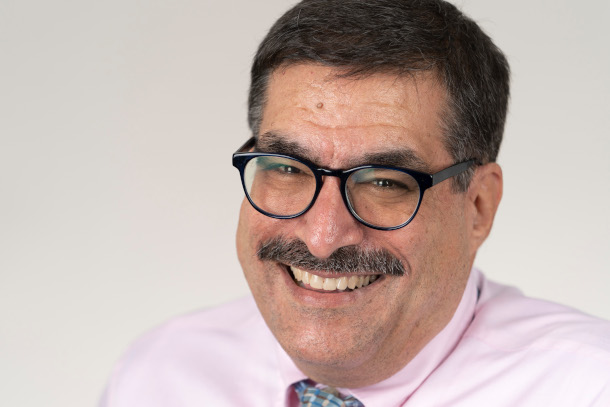
Seth Borenstein is a science writer with the Climate and Environment team at the Associated Press. (Photo: Courtesy of Seth Borenstein)
BORENSTEIN: In the United States, it means fewer Atlantic hurricanes, which are costly, it decreases the chance of costly drought in the Midwest. It increases rainfall in the West, which is, you know, the West often has a problem with drought. So now during this winter, California will have a problem with rain and mudslides, but in general, some studies have shown that the United States actually does better in an El Niño than it does in a La Niña, which brings in more hurricanes and some drought. But the world definitely does not do better in an El Niño.
BELTRAN: So this is really intense, you know, how long is this El Nino sticking around? When can we expect an end to this?
BORENSTEIN: The El Niño should stick around until spring of next year of 2027. It is supposed to peak November, December, maybe January, and then weaken. Luckily, Pacific hurricane season is supposed to end at the end of November, but El Niño has ways of just making things a little chaotic, and it wouldn't be surprising to see one of the Pacific hurricanes go into December. But after the spring, we are forecast to be out of an El Niño, probably into a neutral, and then into a La Niña, or we might double dip back into El Niño.
BELTRAN: Seth Borenstein is a science writer at the Associated Press. Thanks so much for joining us today.
BORENSTEIN: It was a pleasure talking with you, Paloma.
Links
PBS News | “How a Super El Niño Is Fueling Extreme Weather Patterns”
Living on Earth wants to hear from you!
Living on Earth
62 Calef Highway, Suite 212
Lee, NH 03861
Telephone: 617-287-4121
E-mail: comments@loe.org
Newsletter [Click here]
Donate to Living on Earth!
Living on Earth is an independent media program and relies entirely on contributions from listeners and institutions supporting public service. Please donate now to preserve an independent environmental voice.
NewsletterLiving on Earth offers a weekly delivery of the show's rundown to your mailbox. Sign up for our newsletter today!
 Sailors For The Sea: Be the change you want to sea.
 The Grantham Foundation for the Protection of the Environment: Committed to protecting and improving the health of the global environment.
 Contribute to Living on Earth and receive, as our gift to you, an archival print of one of Mark Seth Lender's extraordinary wildlife photographs. Follow the link to see Mark's current collection of photographs.
 Buy a signed copy of Mark Seth Lender's book Smeagull the Seagull & support Living on Earth
© Copyright World Media Foundation. All Rights Reserved
Home | Contact | RSS | Donate | Newsletter