
Planning for Rising Water
Air Date: Week of September 10, 2010
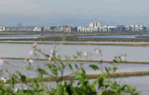
A network of salt production ponds lie below sea level next to San Francisco Bay in Redwood City, Calif. Developers want to turn the area into a small city. ( Dan Honda/Bay Area News Group)
In some places, developers are beginning to build new communities that take into account sea level rise projections. Scenic real estate along low lying land with views of the San Francisco Bay may need special design features to remain desirable. Julia Scott of station KALW in San Francisco reports that there's no guidebook for the work, and approaches vary.
Transcript
YOUNG: It’s Living on Earth. I’m Jeff Young.
[FERRY BUILDING CLOCK RINGS, WAVES]
YOUNG: Most people think of sea level rise as a problem for future generations to deal with. But in San Francisco, planners warn it’s just around the corner. Sea level rise is already happening. Predictions about how much to expect over the coming century vary greatly. The IPCC said oceans could rise two and a half feet. Many other scientists say the rise might be more than twice that.
In San Francisco four and a half feet of sea level rise could put more than one hundred thousand Bay Area homes at risk of flooding. Yet developers there still want to build on low-lying land with million-dollar views. Reporter Julia Scott of San Francisco’s KALW looks at how climate change could change the places we call home.
[TREASURE ISLAND WAVES LAPPING]
SCOTT: At first glance, you couldn’t pick a worse place to build a city than Treasure Island. The island was thrown together out of soft Bay mud in 1935 for the Golden Gate International Exposition. It would liquefy in a major earthquake.
[SOUNDS OF CHILDREN FROM THE BOYS AND GIRLS CLUB, WAVES]
SCOTT: Yet it’s also home to around fourteen hundred people. They bring their kids to the local Boys and Girls Club after school … And they shop at the island’s only convenience store on their way home.
[OUTDOOR SOUNDS]
SCOTT: But Bay Area housing officials believe it could be much more. Engineer Dilip Trivedi works for a group of firms hired to come up with a vision for Treasure Island.
TRIVEDI: As you look out here as we stand, you look at Alcatraz, you look at Angel Island, you look at the Golden Gate and the Bay Bridge. And of course the fabulous, any time of the day or night, you come and you see San Francisco’s downtown skyline here. I mean, it is just an amazing vista.
SCOTT: When Trivedi looks around he sees up to 8,000 homes, five high-rises, public parks, restaurants and a ferry terminal by 2030.
TRIVEDI: Folks are going to come off the Treasure Island free shuttle from the homes itself to that center point on the island and take the ferry, take the bus, kiss and ride, carpools… That’s going to be pretty much downtown.
SCOTT: San Francisco officials hired Trivedi and his engineering firm, Moffatt & Nichol, to make this island habitable and secure in a world with rising sea levels. Developers will have to spend more than a billion dollars on infrastructure before the first home is even built.
The first challenge they’ll deal with is hard to miss. Treasure Island is only two feet above the federal government’s predicted flood line. One corner of the island is already regularly flooded by winter waves.
[TREASURE ISLAND WAVES]
SCOTT: To deal with the threat of flood, they decided to raise the island itself. Hundreds of tons of dirt, packed tight, will make the ground as solid and resilient as the bedrock of neighboring Yerba Buena Island. It will lift the building foundations three feet above the highest 100-year tide.
Trivedi says that even when the sea rises over the next century, the homes will be high and dry.
TRIVEDI: What we are effectively saying is that when the sea level rise itself is 36 inches, the community on Treasure Island is far better than most places along even downtown San Francisco and most places along the Bay themselves.
SCOTT: What made them choose 36 inches? Basically, it’s an educated guess. Cities are free to build by the Bay and choose how to protect the development. Some building proposals are factoring in sea level rise, some not at all.
They can’t get much federal guidance, either. When it comes to building levees, no agency considers the risks of sea level rise - not FEMA, and not the Army Corps of Engineers.
[SOUND OF SALT HARVESTER]
SCOTT: A few miles away in San Francisco’s South Bay, developers are eyeing another waterfront opportunity. One company wants to build the biggest development in half a century on top of a network of salt ponds. These ponds have made salt for 150 years. A salt harvester ploughs across a cloudy pond. These Cargill salt ponds are a stone’s throw away from Silicon Valley.
SMITH: Our vision is to maximize the potential of the site to bring sorely needed housing to a very jobs-rich environment.
SCOTT: That’s David Smith, a vice president with project developer DMB Associates.
SMITH: Between Silicon Valley and San Francisco, this is one of the greatest economic engines in our country.
SCOTT: Where some see a moonscape of red-tinted salt ponds and white slush, Smith sees up to 12,000 homes and one million square feet of office space – along with acres of wetland restoration, playing fields, and a school.
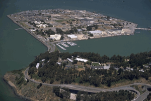
San Francisco's Treasure Island is susceptible to flooding and sea level rise, but developers have a plan to raise the island and build up to 8,000 homes. (Courtesy City of San Francisco)
Unfortunately, most of the site is no more than a foot above sea level. Some of it is even below. That means it would need a levee. And some levee sections would be as high as ten feet, turning the property into a kind of bathtub. That’s a design issue Smith says his company is trying to overcome.
SMITH: If you’re right up against the area, it will be an attractive thing, but you’re not going to want to see a levee and not be able to peek over to the Bay until the third story of your house.
SCHNEIDER: The same questions facing Bay Area cities also confront planners all over the world. Ten percent of the world’s population lives within low-lying coastal zones.
SCHNEIDER: Sooner or later, somebody’s going to have to deal with the backside of our short-term behavior.
SCOTT: The late Dr. Stephen Schneider was a world-renowned climate scientist at Stanford University. He passed away not long after this interview was recorded.
SCHNEIDER: We’re talking something like 15 to 25 feet of potential sea level rise over many centuries if you substantially melt Greenland and just the West Antarctic, the peninsula part. So we are talking about a complete rewrite of the map of the world, it just takes a long time.
SCOTT: As cities begin to plan for sea level rise, they may even re-conceive the nature of settlements, says Will Travis, executive director of the San Francisco Bay Conservation and Development Commission.
TRAVIS: We aren’t building communities anymore; we’re building long-term campgrounds. And if you think of it that way, we may decide to build in a different way. We may decide that the best thing to do is have buildings that are specifically designed to only last 50 or 100 years, and then they can be decomposed, they can be disassembled, they can be moved away.
SCOTT: Back at Treasure Island the redevelopment project doesn’t include floating homes. But Engineer Dilip Trivedi’s team is coping with uncertainty by leaving a 300-foot buffer around the entire island – so future generations can build a sea wall.
A network of salt production ponds lie below sea level next to San Francisco Bay in Redwood City, Calif. Developers want to turn the area into a small city. (Dan Honda/Bay Area News Group)
TRIVEDI: At a point in time where you need 50-feet-high levees on Treasure Island, I mean, there are a lot more problems that are going to happen all around the world, if you will. But within the Bay, Treasure Island will be a pretty safe place to be at.
SCOTT: It’s hard to imagine San Francisco underwater. But it’s a scenario that experts say we ought to be thinking about today. And how we think it through could determine whether our current coastal zones continue to thrive, or are left behind. For Living on Earth, I’m Julia Scott.
Living on Earth wants to hear from you!
Living on Earth
62 Calef Highway, Suite 212
Lee, NH 03861
Telephone: 617-287-4121
E-mail: comments@loe.org
Newsletter [Click here]
Donate to Living on Earth!
Living on Earth is an independent media program and relies entirely on contributions from listeners and institutions supporting public service. Please donate now to preserve an independent environmental voice.
NewsletterLiving on Earth offers a weekly delivery of the show's rundown to your mailbox. Sign up for our newsletter today!
![]() Sailors For The Sea: Be the change you want to sea.
Sailors For The Sea: Be the change you want to sea.
 The Grantham Foundation for the Protection of the Environment: Committed to protecting and improving the health of the global environment.
 Contribute to Living on Earth and receive, as our gift to you, an archival print of one of Mark Seth Lender's extraordinary wildlife photographs. Follow the link to see Mark's current collection of photographs.
 Buy a signed copy of Mark Seth Lender's book Smeagull the Seagull & support Living on Earth
© Copyright World Media Foundation. All Rights Reserved
Home | Contact | RSS | Donate | Newsletter