
Future Outlook
Air Date: Week of June 2, 2006
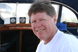
Ivor van Heerden, deputy director of the Louisiana State University Hurricane Center, at the helm of his sailboat, “The Magnum.” (Photo: Steve Curwood)
There are a number of engineering plans on the drawing board that aim to give New Orleans and the Gulf Coast the level of protection they need to fend off hurricanes. Host Steve Curwood examines the feasibility, practicality, and cost to implement some of the major proposals.
Transcript
CURWOOD: It’s Living on Earth, I’m Steve Curwood in New Orleans.
[SOUND OF CONSTRUCTION VEHICLES]
Here at the 17th street canal – where raging storm waters broke through the levee and ravaged a neighborhood – workers race against time to build a flood gate and complete repairs on the dyke as a new hurricane season begins.
Ivor van Heerden, deputy director of the Louisiana State University Hurricane Center, at the helm of his sailboat, “The Magnum.” (Photo: Steve Curwood)
VAN HEERDEN: The barrier islands protect the wetlands. The wetlands protect the levees. The levees protect the home.
CURWOOD: Ivor van Heerden is deputy director of the LSU Hurricane Center and author of the new book, “The Storm: What Went Wrong and Why during Hurricane Katrina.” He hails from South Africa and brings with him international expertise on coastal restoration, along with the perspective of an outsider not so mired in local politics and turf wars.
In the cockpit of his sailboat, “The Magnum.” van Heerden quickly lays out the foundation of what it would take to rebuild the Gulf coast in a comprehensive way that would insure its protection.
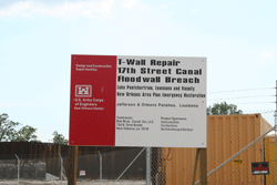
A billboard stands at the border of the massive reconstruction project headed by the U.S. Army Corps of Engineers. (Photo: Steve Curwood)
CURWOOD: Why are wetlands important for protection against hurricanes in New Orleans?
VAN HEERDEN: What we know is that a wetland reduces the storm surge because of the frictional effects as the surge moves through it. This is especially true when the surge is going through a Cyprus swamp because now you have trees that are at least 60 feet high, very well rooted, very well packed. So you imagine trying to push water through that forest, it slows down dramatically.
The second thing is as a hurricane approaches the coast, the right-hand side the winds are blowing to the shore, the left-hand side the winds are blowing out to sea. And so on the left-hand side you actually lower the water level so the plants and levees and the barrier islands stick up into the wind field, and as a consequence they take some of the energy out of the wind field. So the wetlands have two very important roles to play.
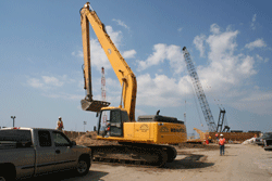
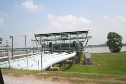
A construction crew erects new floodgates at the 17th St. Canal. (Photo: Steve Curwood)
VAN HEERDEN: The reason we’ve lost as many wetlands as we have reflects the fact that we’ve cut off the sediment supply from the Mississippi River, because of the artificial levees. All that sediment now goes into Gulf waters about 400 foot deep. And in addition we’ve crisscrossed all the wetlands with numerous canals and channels, some for navigation, some for oil and gas, and they’ve totally disrupted the natural function of many of those wetlands.
CURWOOD: How difficult is it to engineer the coastal restoration and the buildup of barrier islands?
VAN HEERDEN: In terms of the barrier islands, all that we need to do is move the sand from offshore about 11 miles, and then you can build up your barrier islands. There are many, many different systems. We’ve perfected beach restoration in the United States; it’s exactly the same technique.
In terms of the wetlands, we know from other examples we have in the central part of the coast that if you can just get the Mississippi water to the wetlands you’ll build little deltas, you’ll rebuild the wetlands and the whole area will rejuvenate.
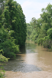
Bayou LaForche, once a major branch of the Mississippi River, would get much more water under plans to restore the delta. (Photo: Steve Curwood)
He heads the coastal engineering division for the Department of Natural Resources and I met him on top of a levee in Donaldsonville, a small town on the Mississippi where both the demise of the wetlands began, but also where they may be reborn.
In 1904, the Mississippi was damned off from the head of the Bayou LaForche, a waterway that sits just a few hundred yards from this levee. The diversion cut off fresh water, nutrients and sediment needed for the healthy survival of the estuaries systems downstream on the Gulf of Mexico, the areas experiencing the greatest rate of wetland loss.
One plan calls for a break in the levee a few miles south of where we stand. Over time this major diversion would create a new river and form a new delta. But Bob Roberts says time is running out.
ROBERTS: What we’re finding out with that is it’s a long-term project. It’s on a scale that we need but in order to get it done it would take approximately 40 to 60 years for our channel to be capable of carrying the amount of water needed to build the delta, and to build delta at a rate that will help offset the loss rate that’s going on in the basins right now. And that’s what our work is showing us.
The existing pumping station at Bayou LaForche. Plans are underway to build a much larger one along this levee. (Photo: Steve Curwood)
ROBERTS: It’s not a land building project, it’s mainly a freshwater and nutrient project. We don’t have the flow capacity within the bayou anymore to carry sediments long distance. But we can get the fresh water where we need it to literally keep salt water at bay and give the fresh water marsh a chance, instead of converting to a saltwater marsh or converting to open waters as a whole. The nutrients also help fertilize that marsh so that it stays healthy.
CURWOOD: But without sand and sediment there’s nothing for the water to replenish. No place to anchor the kinds of vegetation needed to dampen storm surges. That’s where Kerry St. Pe comes in.
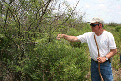
Kerry St. Pe explores the various species able to hold the wetlands in place and survive in the face of hurricanes, including a hearty variety of oak tree. (Photo: Steve Curwood)
ST. PE: Most of these are endangered birds that are flying over head. As you can see it’s heavily used by birds for nesting.
CURWOOD: Kerry St. Pe, who heads the Barataria-Terrebone National Estuary Program, leads me across acres of marsh, carefully pointing out the well-camouflaged eggs of nesting birds, coyotes tracks and sprawling vegetation, as a bevy of willets, least terns, and Wilson’s plovers swirl overhead.
With butterflies lazily floating among flowering bushes and plants, it’s hard to imagine that two major hurricanes, Katrina and Rita, roared through here just several months ago. St. Pe and his partner, Dean Blanchard, take me to the top of an eight foot high ridge, a ridge that, just five years ago, didn’t exist.
Bayou LaForche, once a major branch of the Mississippi River, would get much more water under plans to restore the delta. (Photo: Steve Curwood)
CURWOOD: Using a system of pipes and hydraulic pumps, the St. Pe team scooped up sediments from a dredging operation at nearby Port Fourchon and piled them up where the old photos showed them to be. Then teams went in to plant a variety of grasses, shrubs and trees, looking for species that can flourish in the harsh environment.
[FOOTSTEPS]
St. PE: We always get our picture with Dean next to this tree. That’s how we can show it from year to year, how it’s changed. This one actually had acorns on it. It was stressed pretty badly. It was totally brown after Rita. But you can see there’s a lot of new growth. It’s doing quite well, it’s gonna come back.
CURWOOD: Acorns out here where there used to just be water?
ST. PE: Yes.
CURWOOD: Now you have trees.
St. PE: Now we have trees. That’s the whole idea – building land out of open water. That’s what we need to do in Louisiana on a large scale, quickly.
CURWOOD: So you have a plan to take what you have modeled here and turn this into thousands of acres here in the Mississippi delta area. How’re you going to do this?
ST. PE: Well, we would build a system of hopefully permanent pipelines that would radiate from the Mississippi River from places of deposition, from point bars. You would harvest sediments, use what you can from that site, and move to another site, allowing the other spot in the river that you just harvested to repopulate or resettle sediments. We would look at the offshore sources where, as we’re standing here, we’re within a mile of the Gulf of Mexico. There are sediment sand deposits in the Gulf of Mexico that we could use, and we would use that to build our barrier islands, for example.
CURWOOD: There’s a saying around here, what, Louisianans know how to do best, that is.
ST. PE: Well we’ve certainly laid down a few pipelines in Louisiana, and of course that’s to transport petroleum largely. And let me just point out that when we initially brought this up we were told that we didn’t…the technology to pump great distances really didn’t exist. And my response was, well, gee, you know, we’re pumping a substance of similar thickness and viscosity all over the United States, and we call that oil. Certainly we can pump a solution of muddy water, you know, 40 or 50 miles without any problems.
CURWOOD: There are folks who say "Hey, wait a second, why not have Mother Nature do this? Help her a little bit by making another diversion of the Mississippi, a grand diversion, a third diversion which would slow the Mississippi down and the sediment would naturally come out into these areas and create these wetlands without this high-tech approach of having to build a big super pipeline or sets of pipelines?"
ST. PE: Well there has been examinations of a major new diversion from the Mississippi River. And so far the data that has come out of these studies and evaluations indicates that it would take 60 years before we actually start transporting sediments here. We clearly do not have 60 years. In the short term this pipeline thing is the only way that we can strategically build land exactly where we need it. It is the only way unless someone can point to something that we have not thought of, that no one has thought of. It is the only way that we can build land in the short term.
CURWOOD: If Kerry St. Pe is right – and he has hard ground to prove his point – it could be possible to pipe in enough sediment to make a major difference on the Louisiana coast. But it will be an uphill battle. With global warming, sea levels are projected to rise faster than they have in recent years, and the rate of increase may be dramatic. Again, Ivor van Heerden of the LSU Hurricane Center.
VAN HEERDEN: Louisiana’s been subsiding since time began. So sea level’s been rising for a long, long time, we’ve always managed to deal with it. We just gotta get smart. We gotta recognize that if we build the right levee systems, get the wetlands healthy and get them starting to procreate again, and rebuild the barrier islands, that we can come up with a system that, like the Dutch, could give us one in 10,000 years protection.
The other important thing is New Orleans is the testing ground for the rest of the coastal United States. You know, as sea level rises it’s not just going to be New Orleans that’s gonna have a problem – it’s gonna be Tampa, Long Island, maybe parts of New York, Houston, Galveston, Port Arthur, Texas. All these areas that could in due course have to build their own levee system.
CURWOOD: From what you understand, what’s necessary to put a system in the Gulf Coast region around New Orleans that would provide as much protection as the Dutch 10,000 year system?
VAN HEERDEN: All it requires is the willpower to do it. The United States is a very, very rich country. We’re talking about to get all of coastal Louisiana the so-called Category 5 protection, and rebuild all the wetlands and the barrier islands so we keep the productive fishery going, we keep the oil and gas infrastructure safe – we’re talking about $30 billion. Katrina was a $300 billion disaster. So, you know, it’s almost just a few cents on the dollar really to get the protection we need.
CURWOOD: Now some people say that over the long haul people need to think about giving much of the south coast of Louisiana back to the ocean. Retreating in from where people are now today. What kind of sense does that make to you, if any?
VAN HEERDEN: Well the plan I was outlining does require some retreat from the coast. Because right now if you look at coastal Louisiana, and imagine you spread the fingers of your hand in front of you, our levee systems kind of run along the outside of your fingers. And between each finger you have a “V,” and that’s basically a funnel that a surge can funnel up when we get a big storm. So really what we need to do in terms of that finger is to cut it off at the knuckles and have one line of levees. It’s much shorter in the long run but it runs across the central part of the coastal zone. Those areas that are outside, you have to compensate the people and give them locations inside the protected system.
CURWOOD: How many people right now live outside the protected system you’re talking about?
VAN HEERDEN: It probably amounts to maybe 100,000 at the most. The bottom line in all of this is as you plan it has to be a case of not what’s good for me, but what’s good for everybody. What makes the best sense for the overall population in coastal Louisiana.
CURWOOD: In the months and years ahead that will be the central question Louisianans and the rest of the nation must grapple with. And the merits of the civil and social engineering plans to protect New Orleans and its surrounding coastline will be hotly debated. This question about coastal protection has been going on for decades, at local, state and federal levels, with many proposals but not much action to address future storms.
But Katrina and Rita brought one unwelcome answer for civil engineers and politicians alike. To do nothing, to reach no consensus, to make no decision…is in fact a decision. One that will continue to leave the region vulnerable to the ferocious storms that push in from the Gulf of Mexico.
Links
Louisiana State University Hurricane Center
Ivor van Heerden’s book “The Storm: What Went Wrong and Why During Hurricane Katrina”
LSU Center for the Study of Public Health Impacts of Hurricanes
Living on Earth wants to hear from you!
Living on Earth
62 Calef Highway, Suite 212
Lee, NH 03861
Telephone: 617-287-4121
E-mail: comments@loe.org
Newsletter [Click here]
Donate to Living on Earth!
Living on Earth is an independent media program and relies entirely on contributions from listeners and institutions supporting public service. Please donate now to preserve an independent environmental voice.
NewsletterLiving on Earth offers a weekly delivery of the show's rundown to your mailbox. Sign up for our newsletter today!
![]() Sailors For The Sea: Be the change you want to sea.
Sailors For The Sea: Be the change you want to sea.
 The Grantham Foundation for the Protection of the Environment: Committed to protecting and improving the health of the global environment.
 Contribute to Living on Earth and receive, as our gift to you, an archival print of one of Mark Seth Lender's extraordinary wildlife photographs. Follow the link to see Mark's current collection of photographs.
 Buy a signed copy of Mark Seth Lender's book Smeagull the Seagull & support Living on Earth
© Copyright World Media Foundation. All Rights Reserved
Home | Contact | RSS | Donate | Newsletter