Loop Current Powers Hurricanes
Air Date: Week of September 23, 2005
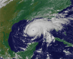
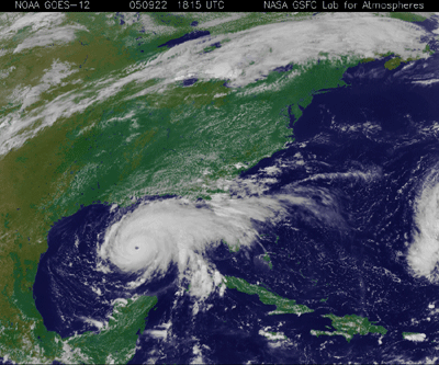
A NASA image shows Hurricane Rita passing over the loop current in the Gulf of Mexico. (Photo courtesy of NASA)
Hurricanes Katrina and Rita were so severe partly because they crossed through a certain ocean loophole. Scientists have been studying what they call "The Loop Current," 100 miles of deep, ultra-warm waters that act to intensify hurricanes. Host Bruce Gellerman talks with professor Nan Walker of Louisiana State University about the latest research.
Transcript
GELLERMAN: From the Jennifer and Ted Stanley Studios in Somerville, Massachusetts, this is Living on Earth. I'm Bruce Gellerman, sitting in for Steve Curwood.
Category 5 hurricanes are rare. They're the most powerful storms, with wind speeds in excess of 155 mph. Over the past 75 years there have been just 28 Cat 5’s in the Atlantic Ocean basin. But this year, for the first time, we’ve had two in one season. Both Hurricane Katrina and Rita began as mild mannered tropical depressions in the Bahamas but within 30 hours had grown into monsters. The reason is the Loop Current.
And joining me from Louisiana State University’s Coastal Studies Institute is Professor Nan Walker. She's director of the Earth Scan Laboratory there. Professor Walker, thank you very much for coming in.
WALKER: It’s nice to be here, Bruce.
GELLERMAN: So, the Loop Current. I’ve heard it described as high test for hurricanes.
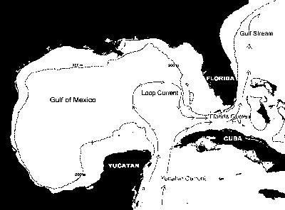
WALKER: Yeah, the Loop Current is actually part of the large scale clockwise gyre of the North Atlantic circulation. Basically, it’s part of this gyre that’s driven by the trade winds in the tropics and the westerlies in the mid-latitudes. And the Loop Current is, it actually is the source of the Gulf Stream. So, if you can imagine one large long ribbon of water flowing around this gyre. It’s a little more complicated than that, but basically it’s the warmest waters in the North Atlantic and the Caribbean Sea. It flows through the Yucatan Straight into the Gulf of Mexico, makes a loop around, and out through the Florida Straight as the Florida Current and then the Gulf Stream.
GELLERMAN: You said “dire”? WALKER: Gyre. Like a clockwise eddy, a huge eddy. GELLERMAN: How big is it? WALKER: Well it’s approximately 100 miles wide, and it’s a very deep warm pool of water. And it flows very rapidly; the waters in the Loop Current and the Gulf Stream are the fastest flowing waters in the Atlantic Ocean. They’re what we call part of the Western Boundary Current of the Atlantic Ocean. GELLERMAN: Sounds very mysterious, actually. How deep is it and how warm? WALKER: The Loop Current is about 800 meters deep. So that’s about 2,400 feet deep. And it’s very warm. It’s warmest at the surface, it’s approximately 85 degrees Fahrenheit at the surface at the moment; and temperatures above 80 degrees are conducive to intensification of hurricanes. GELLERMAN: So, how does the warm water affect the intensity of a hurricane? WALKER: The warm water is actually, it’s called the source of fuel for the hurricane because the winds evaporate the water, at the surface, obviously. And that water becomes the fuel for the hurricane when they condense as rain. And that is the energy source for the hurricane, primarily. GELLERMAN: So, we could have seen this coming? WALKER: Well, it’s more complicated than just, you know, the hurricane moving over the Loop Current. Because the Loop Current is in the Gulf of Mexico probably 95 percent of the time. It’s a normal feature of the Gulf of Mexico. You know, the fuel is there for hurricanes to intensify if they move over that current. However, Hurricane Ivan moved over the Loop Current and it did not intensify as Katrina and, recently, Rita did. So, there are other factors. And probably the key lies in the upper atmosphere, and it has to do with the temperatures and the humidity and the wind.
|